WEATHER AND CLIMATE RISK MANAGEMENT:
indices and scenarios with Climate Sentinel®

The climate emergency is showing signs of systemic recurrence, characterized by severe weather events of increasing frequency and intensity. Such weather phenomena pose a significant threat to all human activities, not just those that take place outdoors or on the land. But even limiting it to the direct damage caused by those events alone — i.e., casualties from natural disasters of climatic, hydrological or meteorological origin — there is a significant increase in claims (Fig. 1), and the resulting loss of human life now constitutes statistical evidence.

Fig. 1 Number of claims made for natural catastrophes in the period 1980-2017. Source: MunicRE - NatCatSERVICE

The required weather and climate mitigation policies must necessarily move through decarbonisation and, therefore, reorganisation of the production scene. Therefore, they require decisions and actions related to credit and investment, which should be implemented by the banking system as a whole. In this area, Climate Sentinel® provides the exploratory tools — the data and technologies — needed to implement policies and also to monitor their outcome.

In general, Hypermeteo develops and processes customized climate risk indices for individual applications that require defining or adopting new policies to deal with the climate emergency, in particular for those operating in the insurance and risk management, energy, agricultural, financial and infrastructure sectors.

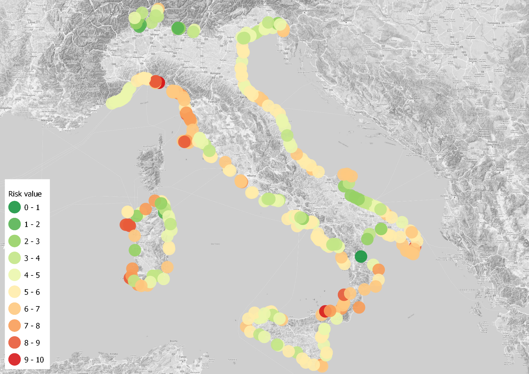
Climate Sentinel® services are designed for all businesses (insurance, financial, banking, real estate, industrial and commercial) that need to consider the impact that ongoing changes in weather and climate can have on their activities and markets. Broadly speaking, for a given geographical area, weather and climate risk indicators can be used to direct investments, guide credit policies, refine property valuation criteria, support production choices and calibrate marketing actions.

The support provided by Hypermeteo makes it possible to adopt quali-quantitative operational criteria, with which to distinguish sectors of economic activity and identify individual assets according to their exposure to climate risks, facilitating classifications based on the degree of vulnerability to a given risk.

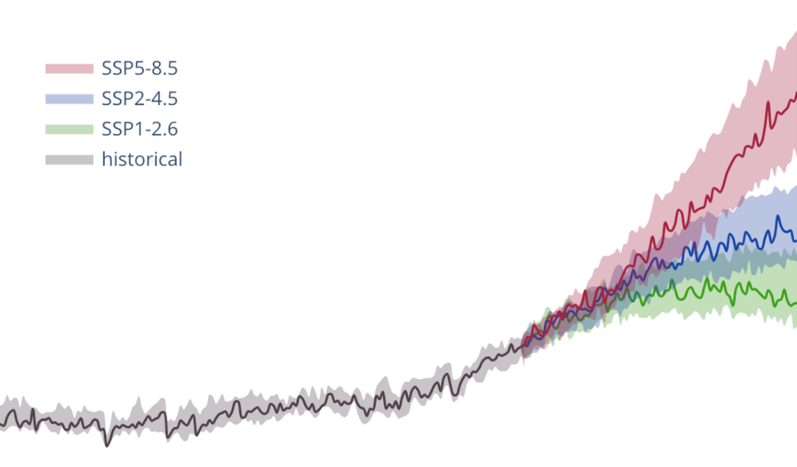
In this area, Hypermeteo not only acts as a data provider but is able to offer two distinct services – Climate Sentinel® index and Climate Sentinel® scenario. They are structured to support climate risk governance through weather data analysis tools that can assess the real, current exposure of the pertinent asset or business to weather-climate risk and then project this into a future scenario featuring a possible — and likely — global change in those weather-climate parameters affecting the risk assessment models themselves.

indicatori di rischio meteoclimatico
Fig.2 Weather risk index

Climate Sentinel® index: climate risk indices

Using its own historical weather dataset, Hypermeteo can determine territorial climate risk indices for all the main adverse weather events (Fig. 2). The weather-climate risk indices developed under the Climate Sentinel® service are subject to constant updating and calibration, performed according to adopted policies and criteria as well as weather-climate trends.

Risk indices are a tool providing an overview that describes the weather-climate risk by considering the likelihood and severity of adverse events. These indicators can also take into account the relationship between several events and the size of the area affected by the weather phenomenon.

They are represented on conventional scales that express the hazardousness of the index reference area. Normally its assumed value is related to the frequency with which the weather event severity measurement parameter exceeds specific critical thresholds established according the asset’s vulnerability to risk.

These indices are generally derived as a combination of various meteorological parameters (e.g., intense rainfall, strong wind, hail), appropriately weighted according to the degree of impact each has in that particular field of application. This provides a summary risk index (Fig. 3) which, in a simple graduated scale, can categorize the territory according to the degree of exposure to the natural events analysed.

On this basis, specific territorial indices are produced that can support operational and decision-making activities in various economic fields. In particular, the weather-climate risk indices are already used in the insurance (e.g., risk of hail) and reinsurance fields since they can guide insurance company commercial policies, making it possible to monitor portfolio balance and the degree of market penetration, calibrate the limits of the guarantees provided (deductible, overdrafts, maximum indemnity) and support analysts in pricing procedures.

Fig. 3 Example of representation of a weather and climate risk indicator.
rischio climatico
Fig. 4 Definition of long-term scenarios

Climate Sentinel® scenario

The new global challenge is ecological transition and the ensuing containment of global warming. It is not so much the warming itself that is of greatest concern, but rather the ensuing change in the frequency and intensity of weather events that will characterise the new climate scenario.

Therefore it is important that climatic knowledge have sound scientific foundations so it can adequately support all climate-related decision-making processes, even in light of the increasing direct participation of the general society in this knowledge and, consequently, in the resulting mitigatory actions. Many decision-making processes require adequate risk assessment and this, in turn, generally requires using reanalysis weather datasets that describe past weather and climate trends; however, in a context of extreme phenomena, the use of historical weather data alone may cause one to underestimate the risks. It is therefore essential to complement this basis with climate projections that provide sufficiently realistic indications of climate trends and, consequently, of their impact, so that an accurate analysis and assessment of climate riskscan be made.

The Climate Sentinel® scenario service aims to meet this need: it uses all available weather data and seeks to define possible impact scenarios (Fig. 4).

Climate Sentinel® scenario uses different weather and climate scenarios to identify the expected extreme values — such as for rainfall and temperature — and their changes over time, providing valuable information with which to define the company’s strategy for adapting to the emergency.

In addition to data on primary meteorological variables (e.g. temperature, wind, precipitation, etc.), parameters are provided to describe and quantify the impact on specific areas.

These indices, also used operationally by Hypermeteo, are an important and effective vehicle of information because they:

  • condense information,
  • focus attention on extremes and, therefore, highlight the trend in, and intensity of, those events having the greatest impact on human activities,
  • are computationally efficient,
  • provide valuable support for decision-making processes.
Fig. 5 Climate projections of average global temperature values

The E3CI climate index is a suite of indicators, updated monthly, that provides concise and intuitive information on the frequency and severity of weather-induced hazards over Europe.